Ainsty (2008) Internal Drainage Board
Ainsty (2008) Internal Drainage Board - Information
The Ainsty (2008) Internal Drainage Board was formed on 1st April 2011 with the amalgamation of the Marston Moore IDB North Wharfe IDB, South Wharfe IDB Acaster IDB and Appleton Roebuck and Copmanthorpe IDB. The Foss (2008) IDB is a Member of the Association of Drainage Authorities (ADA).
The Ainsty (2008) IDB being made up out of the following Districts -
Marston Moor District
This Disrict is in the Vale of York and lies in its south-west quadrant extending to Little Ouseburn, in the north, to Wetherby and Walton, in the south. The old Board was originally made up of three original Boards -
Marston Moor, Ouseburn and Ainsty IDBs
North Wharfe District
This District has two fingers. The first is relatively thin following the River Wharfe from West Ings, through Tadcaster, to a location to the south of the Thorpe Arch Estate near Wighill, the site of the World War II munitions factory. The second, more broader - almost shaped like the letter "Y" - follows a line past the ancient village of Bolton Percy to Oxton, Steeton and Catterton before splitting with one leg heading towards Askham Richard and the other Wighill and Walton Wood.
South Wharfe District
This District lies to the south of the River Wharfe. Its boundary lies just south of Tadcaster, to the west of Cawood and although it lies to the north of Church Fenton it takes in much of the old Church Fenton Airfield.
Acaster District
This District is long and thin in shape, lying within the Vale of York. Its northern boundary is the southern half of Bishopthorpe, a village to the south of York, whereas its eastern and southern boundaries are the Rivers Ouse and Wharfe.
Appleton Roebuck and Copmanthorpe District
This District surrounds the communities of Appleton Roebuck and Copmanthorpe. All the drainage of the District discharges into the Fleet (Old Foss) which then outfalls into the tidal River Wharfe.
| District | Marston Moor | Acaster | North Wharfe | South Wharfe | Appleton & Copmanthorpe |
| Constituted | May 1905 | April 1932 | Before 1954 | October 1948 | January 1934 |
| Area | 9,708ha | 1,350ha | 1,784ha | 2,264ha | 1231ha |
| Length of Maintained Watercourses | 149km | 24km | 45.3km | 36.13m | 32km |
| Area of Agricultural Land | 8,397ha | 1,261ha | 1,725ha | 1,990ha | 1,200ha |
| Area of non-Agricultural Land | 1,311ha | 89ha | 59ha | 274ha | 31ha |
| Number of Pumping Stations | 2 | 1 | 0 | 0 | 0 |
| Area Dependent upon Pumping | 435ha | 20ha | 0ha | 0ha | 0ha |
| Towns and Villages in and around the District | Angram Askham Bryan Askham Richard Bickerton Cowthorpe Great Ouseburn Green Hammerton Hessay Hutton Wandesley Kirk Hammerton Knapton Little Ouseburn Long Marston Moor Monkton Nether Poppleton Nun Monkton Rufforth Thorpe Underwood Tockwith Upper Poppleton Walton Wetherby Whixley Wilstrop York |
Acaster Malbis Acaster Selby Bishopthorpe |
Bolton Percy Catterton Healaugh Newton Kyme Oxton Steeton Tadcaster Wighill |
Barkston Cawood Church Fenton Kirby Wharfe Ozendyke Ryther Skartgingwell Stutton Ulleskelf |
Appleton Roebuck Copmanthorpe |
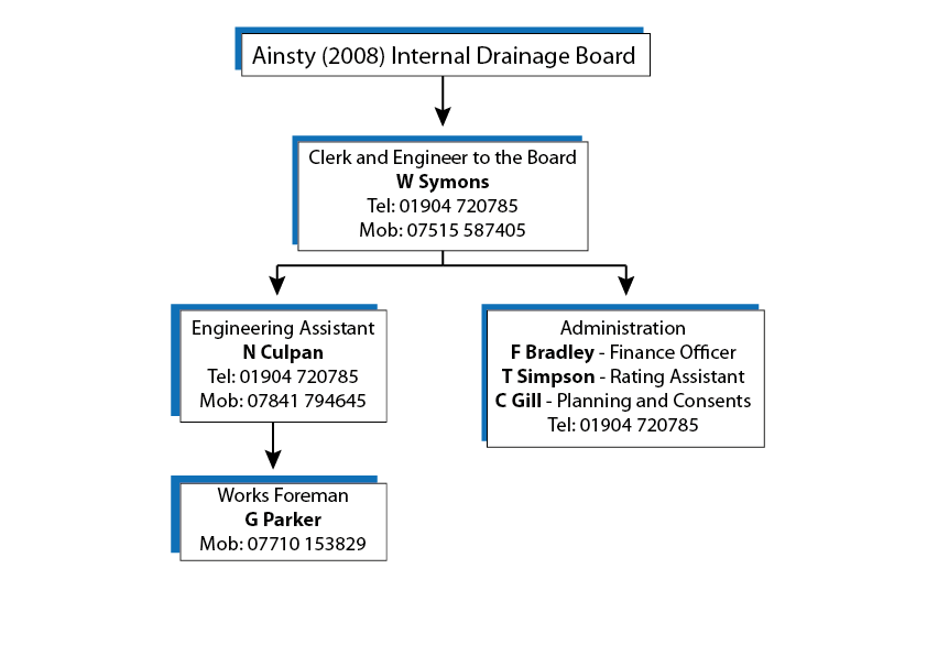
Organisation Chart